Hyperspectral infrared imaging of cuttings using Spectra-Map’s SpecCam instrument was crucial to solving well correlation issues for an Oil and Gas client at a mature oil field in the Northern North Sea. With a lack of core in more recent wells to analyse, interpretation of the sand units at the top of the reservoir was hindered. Standard core logging analyses were performed in an effort to resolve the issues, however methods such as XRD were unable to unravel the characteristics of the formation.
In the pilot study some well-understood core was scanned with SpecCam, together with washed and dried cuttings from the sidetrack, only 60m away. Data was analysed with the MinSpec software in order to define and correlate spectrally derived clay and carbonate mineralogy with the existing drill core and wireline stratigraphy.
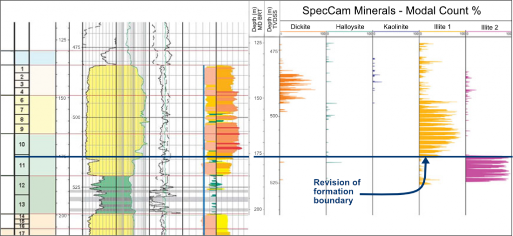
The hyperspectral study, combined with expert spectral interpretation, revealed never before seen differences in the clays in the three formations. The Balta formation was characterised by dickite, while the Tarbert and Ness formations displayed subtle compositional changes in the illite. The study also revealed that the Tarbert sands thickness was greater than previously expected, and led the client to significantly revise the formation boundaries of the well.
Following the success of the pilot study, seven cores and cuttings from several problematic areas of the field were scanned. Some of the cores were nearly 30 years old but they still provided good quality data. The newly discovered mix of clay mineralogies revealed by the SpecCam was fundamental to solving the client’s long standing stratigraphic correlation issues.
If you would like to know more please contact enquiries@spectra-map.co.uk